Summary Report:
The Urban Morphology of Early Bronze Age Sam´al
An Electrical Resistance Tomography Survey of Zincirli, Turkey
Jason T. Herrmann and Virginia R. Herrmann
Institute for Ancient Near Eastern Studies (IANES)
Universität Tübingen
May 2018
Background
Carl Humann played a key role in the first investigations of Zincirli, Turkey, the ancient city of Sam’al. Together with Otto Puchstein, he was the first to document the site on an 1883 expedition. He then organized the permission and funding for the excavations there on behalf of the Deutsches Orient-Comité (DOC) and the Royal Museums of Berlin. Humann led the first season of excavations in 1888, and Zincirli (at that time written Sendschirli) became the first major German excavation project in the Near East beyond Asia Minor, continuing until 1902. Modern investigations by the University of Chicago began in 2006 and have continued since 2014 in partnership with the University of Tübingen (http://zincirli.uchicago.edu).
The 19th century expedition established Zincirli as the site of Sam’al, the capital of one of the Iron Age Syro-Hittite kingdoms (ca. 900–600 BCE) that formed in the wake of the demise of the Hittite Empire. Zincirli became renowned for its geometric urban plan, relief-carved orthostats and gate lions, bit-hilani palaces, and royal inscriptions in Phoenician, ‘Sam’alian,’ Aramaic, and Akkadian. Recently, the joint Chicago-Tübingen team has uncovered evidence of significant settlement at Zincirli also during the Early Bronze Age (ca. 3000–2000 BCE) and Middle Bronze Age (ca. 2000–1600 BCE). It was previously unknown that Early Bronze Age settlement existed not only on the high central mound, but also in a large area underlying the southern part of the circular Iron Age city. This Early Bronze Age lower town is known so far only from small soundings, so its exact extent and shape are unknown. Cities of the Early Bronze Age, the first urban period, are known elsewhere in the broader northern Levant and Anatolia, but Zincirli is the first settlement of urban scale so far identified in the Islahiye Valley of southern Turkey.
Electrical Resistance Tomography and 2017 Prospection
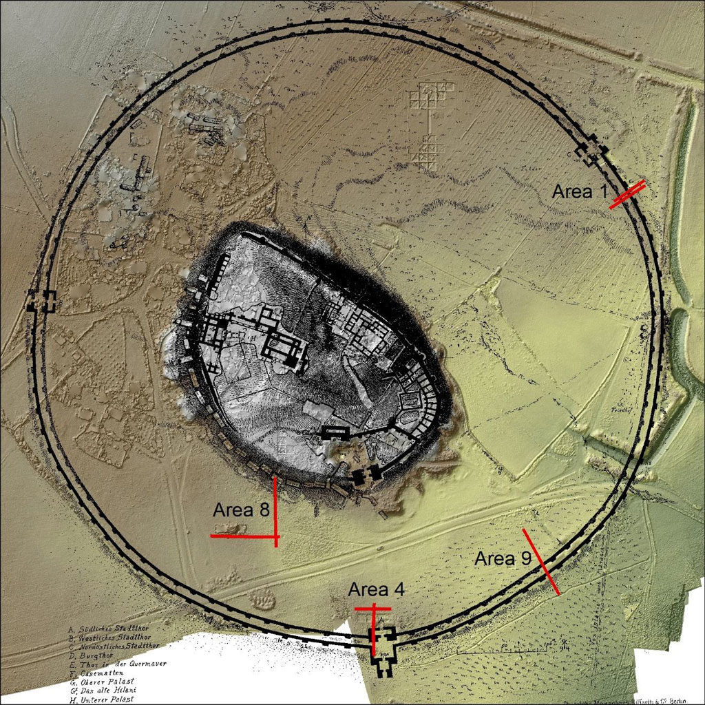
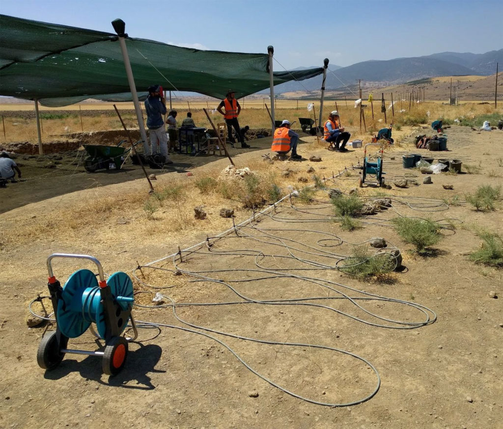
Geophysical prospection at Zincirli Höyük in 2017 funded by the Carl-Humann-Stiftung demonstrates the possibilities and limitations of the use of electrical resistance tomography in delineating the size and shape of the Early Bronze Age lower town and detecting large-scale landscape features. Remote sensing led by Dr. Jason Herrmann, Dr. Virginia Herrmann, and Dr. Tuna Kalaycı (CNR-IBAM, Potenza, Italy) with the assistance of Anomali Jeoteknik (Antalya, Turkey) took place from the 20th to 22nd of August 2017. A multi-channel earth resistivity meter was used to collect electrical resistivity (ER) profiles on the southern edge of the upper mound (near excavation Area 8), near the Iron Age south gate (Area 4), in the southeast lower town (Area 9), and near the northeast gate of the lower town (Area 1) (Figure 1).
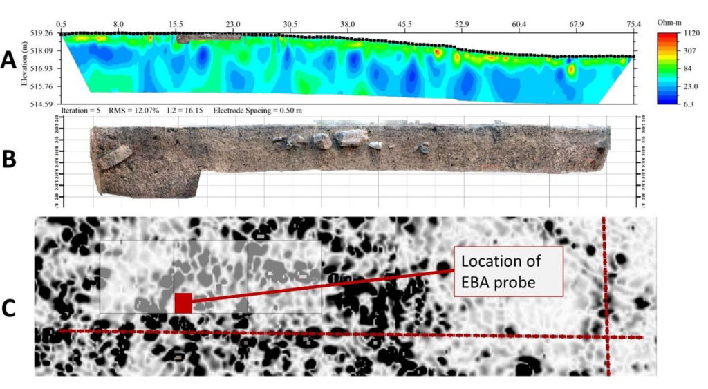
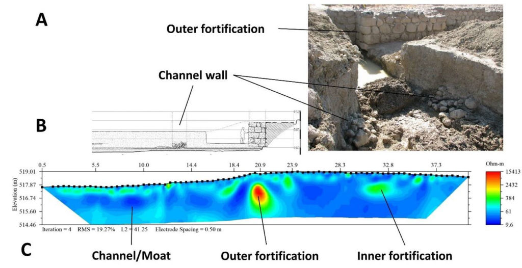
In ER, an electrical current is introduced into the subsurface at evenly spaced points along a line. The ability of that current to flow through buried sediments is recorded for hundreds of locations along the line and at increasing depths. The values are combined to create a resistance profile, an image that shows this resistivity in two dimensions as a vertical ‘slice’ below the surface (Figures 3A and 4C). ER values are primarily influenced by the moisture content of sediments, and to a lesser extent by salt content and compactness. Archaeological and natural horizons below the ground surface are inferred from contrasts in the relative resistance value in the resistance profile images, and can be linked to distinct materials, such as stone, clay, or saturated sediments.
Results
The results of this investigation demonstrate that it is possible, though difficult, to discern phase horizons through ER. In addition, evidence was identified for deeply buried fortification walls, as well as water management features that may have enabled the expansion of the circular Iron Age lower town. Selected results from this pilot project, namely from the search for the Early Bronze Age lower town near excavation Area 8 and from the investigation outside the Iron Age fortifications near Area 1, are summarized here.
Area 8
The goals of ER soundings in the vicinity of excavation Area 8 were to map the interface between the Iron Age and Early Bronze Age occupation strata in the south lower town, and to detect the interface between these cultural deposits and the underlying natural soil. One ER profile collected along the southern edge of excavation Area 8 shows the interface between the Iron and Bronze Age deposits, as demonstrated by comparison with excavated deposits. Figure 3A shows the ER results with a photo of the parallel excavation section superimposed. The deepest part of the excavated section (Figure 3b) shows the top of the Early Bronze layers, and this depth coincides with the transition between the band of high resistance values (green/yellow) and a more conductive horizon (blue) in the ER profile. The correspondence between the depth of the interface between the Bronze and Iron Age levels and the decreasing resistance values in the ER indicate that there is some potential for ER data to distinguish these cultural strata. The distinction between the two levels may indicate a difference in their composition, with the upper levels dominated by stone architecture and the lower levels primarily composed of clay and earth. Alternatively, the places where higher-resistance (green) values dip down to the expected depth of the Early Bronze Age stratum may represent more sparsely distributed Early Bronze Age architectural features. Further work is warranted to understand the relationship between the archaeological deposits and the ER results.
Area 1
In 2009, a long trench was dug perpendicular to and outside of Zincirli’s Iron Age double fortification wall in the attempt to locate the ancient ground surface upon which the city was established and to explore the space immediately outside its massive defenses. The location of a possible water channel was discovered when a pair of bounding walls and distinctive clays were exposed (Figure 4A). The potential channel was difficult to record and study, however, as the trench immediately filled with groundwater when the bounding walls were punctured through excavation (Figure 4B). An ER profile with the same orientation collected in 2017 nearby to the 2009 trench demonstrates that the channel can be mapped through remote sensing (Figure 4C). Additional ER profiles outside of the fortification wall collected in future can help determine if this channel was a moat surrounding the entire site or a canal used only on the eastern side to control mountain runoff and prevent it from damaging the walls and gate.


